Vanport City (historical) Multnomah County, Oregon
Mapped Location
Vanport City (historical): The mapped location is an approximation and should not be used for navigation or wayfinding.
Information
General information on Vanport City (historical)
- Feature Type: Place
Official, historical, colloquial and alternative toponyms for Vanport City (historical)
A brief list of names that this geographic feature has been named
| Name | Description |
|---|---|
| Vanport City (historical) | Official |
Related Catalog Titles
A Bibliography for Vanport City (historical), Multnomah County, Oregon
Vanport by Manly Maben
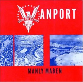
"Vanport City, Oregon, was conceived in 1942 as a temporary housing project for the families of men and women who came to the Pacific Northwest to work in the Kaiser shipyards and further the war effort (World War II). Situated on a flood plain between Vancouver, Washington, and Portland, Oregon, the Columbia River reclaimed the city for its own in a flood on Memorial Day, 1948. In its brief but vital lifetime, Vanport pushed the Portland area into a new era of change and development, leaving a legacy that is felt even today. During its time, Vanport was the largest housing project in the United States, (perhaps the world) and the second largest city in Oregon"--Cover
xiv, 151 pages : illustrations ; 23 cm
CIRC [ 1 ]
Multnomah County
- Alameda
- Arleta
- Barnes Heights
- Bertha (historical)
- Bonneville
- Bonny Slope
- Bridal Veil
- Bridlemile
- Burlingame
- Burlington
- Carson Heights
- Corbett
- Dodson
- Dunthorpe
- Englewood
- City of Fairview
- Faloma
- Folkenberg
- Fulton (historical)
- Gilbert
- Green Hills
- City of Gresham
- Hillsdale
- Holbrook
- Interlachen
- Johns Landing
- Kellogg Park
- Kings Heights
- Latourell
- City of Maywood Park
- Orient
- Plainview (historical)
- Pleasant Home
- City of Portland
- Portland Heights
- Powell Valley
- Powellhurst
- Riverview (historical)
- Riverwood
- Russellville
- South Portland (historical)
- Springdale
- City of Troutdale
- Twelvemile Corner
- University Park
- Vanport City (historical)
- Vermont Hills
- Villa Ridge
- Warrendale
- Westmoreland
- Whitwood Court
- Willamette Heights
- City of Wood Village
- Woodstock
Political Boundaries
Last updated: 2016-10-01