Salmon Creek Clark County, Washington
Mapped Location
Salmon Creek: The mapped location is an approximation and should not be used for navigation or wayfinding.
Information
General information on Salmon Creek
- Feature Type: Place
Official, historical, colloquial and alternative toponyms for Salmon Creek
A brief list of names that this geographic feature has been named
| Name | Description |
|---|---|
| Salmon Creek | Official |
A Selected Bibliography of Salmon Creek, Clark County, Washington
A compilation of essential readings detailing the history, geography, and culture of the region.
The way it was oral histories from Salmon Creek & Deep River by Ruth Busse Allingham
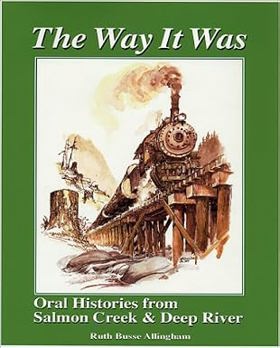
Ruth Busse Allingham’s The way it was: oral histories from Salmon Creek & Deep River provides a vital, firsthand chronicle of immigrant settlement and early industrial labor along the dense tidewater sloughs of the lower Columbia River estuary. Set against the rugged watersheds of Wahkiakum County, the narrative weaves together personal accounts to detail how predominantly Finnish and Scandinavian pioneers mapped their remote logging camps, dairy farms, and salmon canneries directly onto the riverine networks and trade routes long navigated by the Chinookan peoples. The text reveals the immense physical demands of early twentieth-century resource extraction, highlighting how these isolated workers relied on deep community bonds and interdependent alliances to survive unpredictable tidal systems and grueling economic cycles. Ultimately, this collection functions as an essential grassroots history, documenting how the cooperative endurance of rural immigrant families—and their reliance on established indigenous waterway geography—successfully transformed a wild coastal frontier into enduring, culturally distinct enclaves.
152 pages : illustrations, map ; 28 cm
Desiderata
Clark County
- Alpine
- Amboy
- Baker
- Barberton
- City of Battle Ground
- Battle Ground West
- Blurock Landing
- Brush Prairie
- Burton
- Burton Homes
- City of Camas
- Cathlapotle (historical)
- Cedarville
- Charter Oak
- Chelatchie
- Cherry Grove
- Crawford
- Creswell Heights
- Dayton
- Dole
- Dollar Corner
- Etna
- Fargher Lake
- Felida
- Fern Prairie
- Fisher
- Five Corners
- Good Hope
- Hall
- Hayes
- Hazel Dell
- Heisson
- Hidden
- Highland
- Hockinson
- Homan
- Image
- Ireland
- King Corner
- Knapp
- Kumtux
- City of La Center
- Lake Shore
- Lakeshore
- Lambert
- Lewisville
- Little Elkhorn
- Livingston
- Lucia
- Manor
- McLoughlin
- Meadow Glade
- Mill Plain
- Minnehaha
- Moulton
- Mount Pleasant
- Mount Vista
- Officers Row
- Orchards
- Parker Landing Light
- Parkersville
- Pine Grove
- Pioneer
- Proebstel
- City of Ridgefield
- Russell Landing
- Rye
- Saint John
- Salmon Creek
- Sara
- Scotton Corner
- Sifton
- Sunnyside
- Union
- City of Vancouver
- Vancouver Junction
- Venersborg
- View
- Walnut Grove
- City of Washougal
- West Pioneer
- Town of Yacolt
Political Boundaries
Last updated: 2008-03-21