City of Courtenay Comox Valley Regional District, British Columbia
Mapped Location
City of Courtenay: The mapped location is an approximation and should not be used for navigation or wayfinding.
Information
General information on City of Courtenay
- Feature Type: Incorporated
Official, historical, colloquial and alternative toponyms for City of Courtenay
A brief list of names that this geographic feature has been named
| Name | Description |
|---|---|
| City of Courtenay | Official |
Related Catalog Titles
A Bibliography for City of Courtenay, Comox Valley Regional District, British Columbia
Watershed moments a pictorial history of Courtenay and district by Christine Dickinson , Judy Hagen , Deborah Griffiths , Catherine Siba , Courtenay and District Museum (Issuing body)
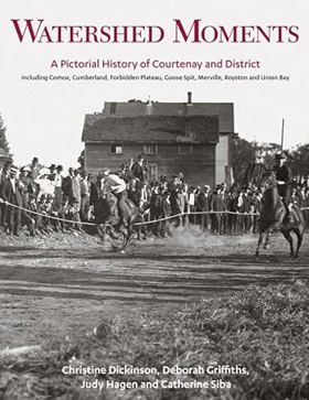
"In Watershed Moments, the Courtenay and District Museum opens its vast collection of historical photographs, glass plate negatives and other ephemera, much of which has never before been available to public viewing. Spanning from the late 1800s to the modern era, here are scenes of K'ómoks village life, boating parties, family celebrations, agricultural events and economic activities. This visual depiction of the development of this region is reinforced by a lively text, drawing heavily on the museum's vast holdings of primary source material."-- Provided by publisher
xi, 195 pages : illustrations (some color), maps, portraits (some color) ; 29 cm
CIRC [ 1 ]
Comox Valley Regional District
- Balmoral Beach
- Bevan
- Black Creek
- Buckley Bay
- Town of Comox
- City of Courtenay
- Village of Cumberland
- Denman Island
- Fanny Bay
- Fanny Bay
- Grantham
- Headquarters
- Hornby Island
- Hornby Island
- Lazo
- Little River
- Merville
- Mount Washington
- Mud Bay
- Oyster River
- Puntledge
- Royston
- Sandwick
- Saratoga Beach
- Union Bay
- Williams Beach
Political Boundaries
Last updated: 2025-09-23