Ozette Clallam County, Washington
Mapped Location
Ozette: The mapped location is an approximation and should not be used for navigation or wayfinding.
Information
General information on Ozette
- Feature Type: Place
Official, historical, colloquial and alternative toponyms for Ozette
A brief list of names that this geographic feature has been named
| Name | Description |
|---|---|
| Ozette | Official |
Origin Notes and History of Ozette
References to Ozette that document the origin of its place name

OZETTE, the name of a lake and a town on its shores, a creek, an island and an Indian Reservation, all near the Pacific Ocean, in the western part of Clallam County. The name is mentioned in the treaty by Governor Isaac I. Stevens with the Makahs, January 31, 1855. In an address at Port Townsend in 1887, Judge James G. Swan said: "There is a lake five or six miles inland from Hozett village at Flattery Rocks, which is marked on the coast survey charts 'Lake of the Sun.' The Makah name is Ka'houk, meaning a large body of fresh water, or simply lake. The sun part is imagination." (Transactions of the Washington Pioneer Association, 1883-1889, pages 100-101).
Related Catalog Titles
A Bibliography for Ozette, Clallam County, Washington
Ozette excavating a Makah whaling village by Ruth Kirk
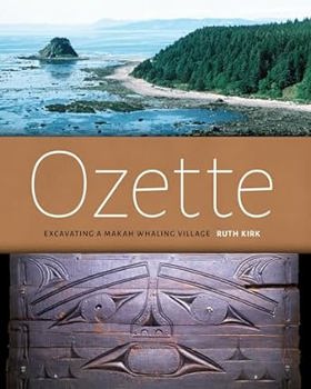
Makah families left the coastal village of Ozette in the 1920s to comply with the federal government's requirement that they send their children to school, and by doing so they ended nearly 2000 years of occupation at this strategic whale- and seal-hunting site on Washington's Olympic Peninsula ologist Richard Daugherty took note of the site in a survey of the coast in 1947 and later returned at the request of the Makah tribal chairman when storm waves began exposing both architecture and artifacts. Full-scale excavations from 1966 to 1981 evealed houses and their contents--including ordinarily perishable wood and basketry objects that had been buried in a mudflow well before the arrival of Europeans in the region
xvii, 102 pages : illustrations, maps ; 26 cm
CIRC [ 1 ]
Clallam County
- Agnew
- Beaver
- Bell Hill
- Blyn
- Carlsborg
- Clallam Bay
- Classet
- Coville
- Crane
- Crescent
- Disque
- Dungeness
- Elwha
- City of Forks
- Happy Valley
- Jamestown
- Joyce
- King Hill
- La Push
- Little Oklahoma
- Lower Elwha
- Maple Grove
- Midway
- Mora
- Mount Pleasant
- Neah Bay
- Old Royal
- Old Town
- Olympic Hot Springs
- Ovington
- Ozette
- Piedmont
- City of Port Angeles
- Port Crescent
- Port Williams
- Pysht
- Quillayute
- R Corner
- Ramapo
- Rena
- River Road
- Sappho
- Sekiu
- City of Sequim
- Shadow
- Shuwah
- Snug Harbor
- Tsoo-Yess
- Twin
- Waatch
- Washington Harbor
- Whiskey Bend
- Windy Arm
Political Boundaries
Last updated: 2025-09-23