Lummi Island Whatcom County, Washington
Mapped Location
Lummi Island: The mapped location is an approximation and should not be used for navigation or wayfinding.
Information
General information on Lummi Island
- Feature Type: Place
Official, historical, colloquial and alternative toponyms for Lummi Island
A brief list of names that this geographic feature has been named
| Name | Description |
|---|---|
| Lummi Island | Official |
Origin Notes and History of Lummi Island
References to Lummi Island that document the origin of its place name

LUMMI, the name of a tribe of Indians in Whatcom County, which has been applied to a bay, Indian reservation, Island, point, river and rocks, all in the vicinity of Bellingham Bay. The Spanish chart of 1792 by Galliano and Valdes show Lummi Bay, northwest of Lummi Island as "Ensenada de Loera." ( United States Public Documents, Serial Number 1557, chart L.) Lummi Island was given the Spanish name of "Isla de Pacheco," which was part of the long name of the Viceroy of Mexico. ( See Guemes, pages 105-106) The Wilkes Expedition, 1841, changed the name to "McLaughlin's Island," an honor intended for Dr. John McLaughlin, Chief Factor of the Hudson's Bay Company at Fort Vancouver. The name was again changed in 1853 by the United States Coast Survey to Lummi Island "because inhabited by that tribe." (Pacific Coast Pilot, page 567, note.) That name has been used on all subsequent charts and has been applied to several other geographic features in the neighborhood. The Bureau of American Ethnology says the Lummi tribe was quite distinct from the Nooksak tribe neighboring on the north. (Handbook of American Indians, Part I., page 778.)
Related Catalog Titles
A Bibliography for Lummi Island, Whatcom County, Washington
To fish in common the ethnohistory of Lummi Indian salmon fishing by Daniel L. Boxberger , Chris Friday
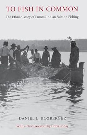
"By focusing on the history of control over productive resources (in this case salmon, methods of harvest, processing, capital investment, and markets) Boxberger shows how the Lummi slid from independence and self-sufficiency to dependency, underdevelopment, and poverty. . . . Not only is it an excellent, in-depth study of the Lummi case, it can also serve as a metaphor for the larger question of Native American treaty rights and the resource provisions of agreements." --Pacific Historical Review
xviii, 212 pages : illustrations ; 22 cm.
CIRC [ 1 ]
Whatcom County
- Acme
- Agate Bay
- Alabama Hill
- Alderwood
- Anacortes Crossing
- Balford
- Barron
- Beach
- City of Bellingham
- Birch Bay
- Birch Bay Circle Grange
- Birchwood
- City of Blaine
- Blue Canyon
- Boundary
- Boundary Bay
- Brennan
- Cedar Crossing
- Cedarville
- Chuckanut
- Clearbrook
- Clipper
- Columbia
- Comar
- Cottonwood Beach
- Custer
- Delta
- Deming
- Dewey
- Diablo
- Doran
- Eureka
- City of Everson
- Fairhaven
- City of Ferndale
- Forest Ridge
- Geneva
- Glacier
- Goshen
- Greenwood
- Gulfaire Mobile Villa
- Hampton
- Haynie
- Hillsdale
- Huntingdon
- Kendall
- Kickerville
- Kulshan
- Lakeway
- Larson Mill
- Laurel
- Lawrence
- Limestone Junction
- Lummi
- Lummi Island
- City of Lynden
- Maple Beach
- Maple Falls
- Marietta
- Mirror Lake
- Mountain View
- Neptune Beach
- Newhalem
- City of Nooksack
- Nooksack Salmon Hatchery
- Noon
- Northwood
- Nugents Corner
- Parkview
- Peaceful Valley
- Pleasant Valley
- Point Roberts
- Roosevelt
- Ruby (historical)
- Saxon
- Semiahmoo
- South Beach
- Sudden Valley
- City of Sumas
- Sunnyside
- Tenmile
- Tsawwassen Beach
- Van Wyck
- Van Zandt
- Victor
- Wahl
- Warnick
- Washington Colony (historical)
- Welcome
- Wickersham
Political Boundaries
Last updated: 2024-06-03