City of Bainbridge Island Kitsap County, Washington
Mapped Location
City of Bainbridge Island: The mapped location is an approximation and should not be used for navigation or wayfinding.
Information
General information on City of Bainbridge Island
- Feature Type: Incorporated
Official, historical, colloquial and alternative toponyms for City of Bainbridge Island
A brief list of names that this geographic feature has been named
| Name | Description |
|---|---|
| City of Bainbridge Island | Official |
| Bainbridge Island | Official |
Origin Notes and History of City of Bainbridge Island
References to City of Bainbridge Island that document the origin of its place name

BAINBRIDGE ISLAND, in Kitsap County. The Wilkes Expedition, 1841, by discovering Agate Passage, made known the existence of the island. It was named in honor of Captain William Bainbridge, hero of the Constitution in the Java action, and one of the famous men in United States naval records.
Related Catalog Titles
A Bibliography for City of Bainbridge Island, Kitsap County, Washington
They Cast a Long Shadow. A History of the Nonwhite Races on Bainbridge Island by Brian, Ed Roberts, Bainbridge Island School District 303, WA
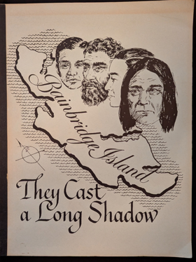
Written as a curriculum aid for students in the Bainbridge Island, Washington school district, this collection of stories about the Japanese, the Chinese, the Hawaiians, the Filipinos, the Vietnamese, and the American and Canadian Indians is an attempt to explain "what life is like for people who look different". The stories all relate the history of each of these ethnic groups on Bainbridge Island, an agricultural community, from the time of their arrival through the present. Accounts of individual's experiences from each group and black and white photographs are used to illustrate the stories. (PR)
122
CIRC [ 1 ]
Kitsap County
- Agate Point
- Bainbridge
- Bainbridge Grange
- City of Bainbridge Island
- Bangor
- Banner
- Battle Point
- Bethel
- Breidablick
- City of Bremerton
- Bremerton Junction
- Brownsville
- Burley
- Central Valley
- Charleston
- Chico
- Colby
- Colchester
- Conifer Park
- Country Lane
- Creosote
- Crosby
- Crystal Springs
- Eagledale
- East Bremerton
- East Port Orchard
- Eastwood
- Eglon
- Eldorado Hills
- Enetai
- Erlands Point
- Fairview
- Ferncliff
- Fernwood
- Fletcher Bay
- Fort Ward
- Four Corners
- Fragaria
- Gilberton
- Glenwood
- Gorst
- Hansville
- Harper
- Hawley
- Hintzville
- Hite Center
- Holly
- Huckle Ridge
- Illahee
- Indianola
- Jackson Park
- Johansons Corner
- Kariotis
- Keyport
- Kingston
- Kitsap Lake
- Lawters Beach
- Lemolo
- Lincoln
- Little Boston
- Lofall
- Lynwood Center
- Madrona Heights
- Madrona Point
- Manchester
- Manette
- Manitou Beach
- Manzanita
- Meadowdale
- Naval Depot Junction
- Navy Yard City
- Nellita
- Olalla
- Olympic View
- Orchard Heights
- Parkwood
- Parkwood East
- Pearson
- Point White
- Port Blakely
- Port Gamble
- Port Madison
- City of Port Orchard
- City of Poulsbo
- Retsil
- Rocky Point
- Rollingbay
- Rose Point
- Scandia
- Seabeck
- Seabold
- Sheridan
- Sherman Heights
- Silverdale
- South Beach
- South Colby
- Southworth
- Striebels Corner
- Sunnyslope
- Sunset Farm
- Suquamish
- Tolo
- Tracyton
- Treemont
- Trikkala
- Twin Spits
- Venice
- Vinland
- Virginia
- Warrenville
- Waterman
- Waterman Point
- Wautauga Beach
- West Blakely
- West Port Madison
- Westwood
- Wildcat Lake
- Wildwood
- Yeomalt
Political Boundaries
Last updated: 2017-02-12