City of Walla Walla Walla Walla County, Washington
Mapped Location
City of Walla Walla: The mapped location is an approximation and should not be used for navigation or wayfinding.
Information
General information on City of Walla Walla
- Feature Type: Incorporated
Official, historical, colloquial and alternative toponyms for City of Walla Walla
A brief list of names that this geographic feature has been named
| Name | Description |
|---|---|
| City of Walla Walla | Official |
| Walla Walla | Official |
| Wieletpu | Historical |
Origin Notes and History of City of Walla Walla
References to City of Walla Walla that document the origin of its place name

WALLA WALLA is one of the most beautiful and best established Indian names in the geography of Washington.. It is applied to a county, city and river in the southeastern part of the State. The origin of the name is easily ascertained as it was recorded by the first white men who visited that region. Elliott Coues, the scholarly editor of the Lewis and Clark Journals, commenting on their entry for April 26, 1806, discusses the word as follows: "Here Lewis K 82 has Wollah Wollah; Clark Q 112 has Wallow Wallows; map has Wollaw Wollah; Clark elsewhere Woller Woller. As earlier observed in this work, the codices vary greatly in this slippery word, more than 20 forms of which are also found in print. Accepted forms are now [1893] Walla Walla, or Walla-walla, or Wallawalla. In several languages walla means running water, and reduplication of word diminutizes it; so Wallawalla is the small rapid river." (Volume III., page 969, note 22.) The word thus first recorded as the name of a tribe of Indians was soon naturally applied to the region occupied by them. In fact the name was taken by the Indians because it described the land where they lived. Rev. Myron Eells, who was born on Walker's Prairie, at the mission home of his father, Rev. Cushing Eells, and who died at the Twana Indian Mission, Hood Canal, in 1907, having devoted his life to work among Indians, wrote: "Walla Walla is a Nez Nerce and Cayuse word, the root of which is walatsa, which means 'running'; hence 'running water'. Two meanings of it are given, one being 'a small stream running into a large one' -- that is, the Walla Walla river emptying into the Columbia; another is 'ripple after ripple', 'fall after fall'. These meanings were given the writer by Mr. P. M. Whitman and Dr. W. C. McKay, who have lived among the Indians most of the time for over forty-five years, and speak the Walla Walla language as fluently as they do the English." (American .Anthropologist Volume V., January, 1892, page 34.) A later student says the Walla Walla Indians are known to the Nez Perces as Walawalapu, "Little River People". (E. S. Curtis, The North American Indian, Volume VIII., page 163.) The geographic name was thus first established for the valley and the river. Near the mouth of the river the North West Company of Montreal built their Fort Nez Perces in 1818, which has been known as "Old Fort Walla Walla." See Fort Walla Walla. The Territorial Legislature passed an act, approved on April 25, 1854, to organize Walla Walla County. On June 9, 1855, Isaac I. Stevens, Governor and Superintendent of Indian Affairs for Washington Territory, and Joel Palmer, Superintendent of Indian Affairs for Oregon Territory, concluded a treaty with the "Walla-Walla, Cayuses, and Umatilla Tribes and Bands of Indians in Washington and Oregon Territories." In that treaty the place of negotiation is given as "the treaty ground, Camp Stevens, in the Walla Walla valley." That site was within the present City of Walla Walla. Immediately following this and other treaties the Indian war broke out, during which Lieutenant Colonel Edward Jevnor Steptoe established Fort Walla Walla. On October 27, 1856, he wrote to his sister: "Do you know where this place is? Look up the Columbia River on the map till you see its tributary, the Walla Walla, and on this latter 'The Mission'. About five miles above the last place I am erecting a Post." (B. F. Manring, The Conquest of the Coeur D'Alenes, Spokanes and Palouses, pages 270-271.) Near that fort grew the City of Walla Walla, affectionately known as the "Garden City." Changes of name are well documented in the following quotation: "There was no town of Walla Walla in 1858; there was in 1859, and it came into existence through the ex parte rules of the first board of county commissioners. The first two meetings of the board were held March 15th and 26th, 1859. In their official record the place was referred to as Walla-Walla. And then, without further notice, we find that at their subsequent meetings January 6th and July 2d, it was called 'Steptoeville', in the record of the last named date appearing the following: 'On motion the name of the town of Steptoeville was changed to Wieletpu'. Despite this official action we find that at the meeting held September 5th, the county seat town is still referred to as Steptoeville. But at the next meeting, November 7th, the town is spoken of as Walla-Walla, and the following proceeding is recorded as regards the name: 'On motion the town of Wieletpu was changed to Walla-Walla.'" (History of Southeastern Washington, page 115.) By act of the Territorial Legislature, approved January 11, 1862, Walla Walla City was regularly incorporated.
Related Catalog Titles
A Bibliography for City of Walla Walla, Walla Walla County, Washington
Becoming Walla Walla the transformation of cayuse country, 1805-1879 by Dennis Crockett
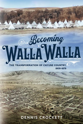
Becoming Walla Walla covers Walla Walla Valley history from the time of the Sahaptian Peoples’ first encounters with Euro-Americans to the initial expiration of the U.S. government’s treaty with the Cayuse, Walla Walla, and Umatilla. It sheds light on the city’s and reservation’s simultaneous development, re-animates the Walla Walla of the 1860s and 70s, reconsiders its status in early Washington Territory and Oregon State histories, and documents transformations of the region’s built and natural environments.
320 pages : illustrations
CIRC [ 0 ]
Walla Walla, a town built to be a city, 1900-1919 by Robert Allen Bennett
Journal of a Catholic bishop on the Oregon trail the overland crossing of the Rt. Rev. A.M.A. Blanchet, Bishop of Walla Walla, from Montreal to Oregon Territory, March 23, 1847 to January 23, 1851. Blackrobe buries Whitmans by Augustine Magloire Alexander Blanchet, Edward J. Kowrach, J. B. A. Brouillet
An illustrated history of Walla Walla County, state of Washington by W. D. Lyman

Published in 1901, W. D. Lyman’s comprehensive volume chronicles the pioneer settlement, agricultural expansion, and civic maturation of Walla Walla County in southeastern Washington. A keen insight drawn from the text is how Walla Walla's strategic evolution from a chaotic gold-rush supply post into a highly stable, wheat-producing powerhouse allowed it to economically and politically dominate the early Washington Territory long before the rise of the Puget Sound cities. The narrative meticulously details this transformation alongside the complex pioneer interactions with Native American tribes, including the profound regional impact of the Whitman Massacre. Like similar historical works of its era, the book ultimately serves as a vital genealogical archive by preserving hundreds of detailed biographical sketches of the resilient farmers, merchants, and civic leaders who built the region.
ONLINE CIRC [ 1 ]
Walla Walla County
- Adkins
- Ash
- Attalia
- Ayer
- Babcock
- Baker-Langdon
- Berryman
- Bolles
- Burbank
- Burbank Heights
- Buroker
- Burr
- Calhounville
- Chew
- Climax
- Clyde
- City of College Place
- Coppei
- Dixie
- Dixie Crossing
- Eastman
- Elwood
- Ennis
- Eureka
- Five Points
- Gardena
- Garrett
- Gilliam
- Hadley
- Harbert
- Harsha
- Harvey
- Hatch
- Humorist
- Hunt
- Kibler
- Kooskooskie
- Lamar
- Langdon
- Le Grow
- Lee
- Lowden
- Magallon
- Matthew
- Minnick
- Mojonnier
- Paddock
- Page
- Pedigo
- Pickard
- Port Kelley
- City of Prescott
- Reese
- Rifton
- Robinson
- Rulo
- Russell
- Ruxby
- Sapolil
- Scott
- Sheffler
- Slater
- Stateline
- Sudbury
- Thiel
- Thomas
- Tompkins
- Touchet
- Tracy
- Two Rivers
- Valley Grove
- Villard Junction
- Waiilatpo (historical)
- City of Waitsburg
- Walker
- City of Walla Walla
- Wallula
- Wallula Junction
- Welland
- Whitman
- Zangar Junction
Political Boundaries
Last updated: 2025-09-23