District of Bowen Island Metro Vancouver Regional District, British Columbia
District Municipality (1) - A populated place with legally defined boundaries, incorporated as a district municipality under the provincial Municipal Act. Entrance to Howe Sound, just W of West Vancouver, New Westminster Land District
Mapped Location
District of Bowen Island: The mapped location is an approximation and should not be used for navigation or wayfinding.
Information
General information on District of Bowen Island
- Feature Type: Incorporated
Official, historical, colloquial and alternative toponyms for District of Bowen Island
A brief list of names that this geographic feature has been named
| Name | Description |
|---|---|
| District of Bowen Island | Official |
Origin Notes and History of District of Bowen Island
References to District of Bowen Island that document the origin of its place name
Bowen Island (Post Office & Steamer Landing) adopted 7 December 1937 on 92G/6, as labelled on BC map 2B, 1914. Form of name changed to Bowen Island (Community) 15 December 1982 on 92 G/6. Incorporated as a District Municipality, to be known as Bowen Island Municipality, per Letters Patent: Order in Council 1160, 2 September 1999, effective 4 December 1999. Form of name confirmed as Bowen Island (District Municipality) 15 March 2000 on 92G/6.
Bowen Island Post Office was opened 1 November 1894. See Bowen Island (island).
The island was named in 1860 by Captain Richards, RN, after Rear Admiral James Bowen (1751-1835), master of HMS Queen Charlotte, flagship of Admiral Earl Howe, at the battle of the "Glorious First of June", 1794, and who, for his valuable and exceptional services on the occasion of this memorable victory, was specially promoted to the rank of lieutenant....
Related Catalog Titles
A Bibliography for District of Bowen Island, Metro Vancouver Regional District, British Columbia
Bowen Island, 1872-1972 by Irene Howard
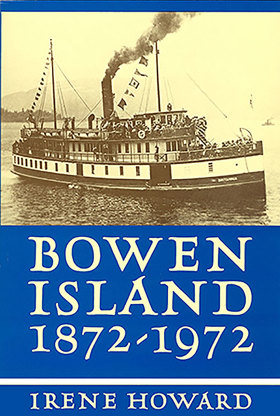
BC writer Irene Howard has woven together years of correspondence, historical records, anecdotes, and interview material to create this textual account of Bowen Island history. The book covers the lives of the early settlers, the days of the steamships, significant events, and notable islanders who have shaped the Bowen Island we now know.
190 pages, 10 unnumbered leaves of plates illustrations, maps, portraits 24 cm
CIRC [ 1 ]
Related Online Resources
Átl’ka7tsem | Howe Sound Marine Reference Guide
A Marine Reference Guide (interactive map) that displays data associated with Átl’ka7tsem’s ocean and watersheds. This will support decision-making, marine spatial planning, and community education by visualizing how human and natural systems interact and overlap.
WEB LINK
Metro Vancouver Regional District
- Albion
- Alder Creek
- Aldergrove
- Altamont
- Ambleside
- Village of Anmore
- Anniedale
- Arbutus Ridge
- Austin Heights
- Barnet
- Barnston Island
- Beach Grove
- Village of Belcarra
- Belvedere
- Bergs
- Birchland Manor
- Blueridge
- Bowen Bay
- District of Bowen Island
- Brentwood Park
- Bridgeview
- Brighouse
- Brighton Beach
- British Properties
- Broadmoor
- Brookswood
- Brunette Creek
- Brunswick Beach
- Buckingham Heights
- Buntzen Bay
- Burkeville
- City of Burnaby
- Burnaby Heights
- Burquitlam
- Canyon Heights
- Capilano Highlands
- Capitol Hill
- Cariboo
- Carraholly
- Cascade
- Cascade Heights
- Cassin
- Caulfeild
- Cedardale
- Chineside
- Cleveland Park
- Cloverdale
- Coldwell Beach
- Connaught Heights
- Coombe
- City of Coquitlam
- Cosy Cove
- Cove Cliff
- Cowans Point
- Crescent
- Crescent Beach
- Cypress Park
- Dartmoor
- Deep Cove
- Delbrook
- District of Delta
- Delta
- Dollarton
- Douglas
- Dunbar-Southlands
- Dundarave
- Eagle Harbour
- Eagle Ridge
- Eastburn
- Elgin
- Essondale
- Fairview
- Fern Ridge
- Fernlee
- Fleetwood
- Forest Hills
- Forest Knolls
- Fort Langley
- Frames
- Fraser Heights
- Fraser Mills
- Garden Village
- Glen Valley
- Glenbrooke North
- Gleneagles
- Glenmore
- Grandview
- Grandview-Woodlands
- Granite Falls
- Guildford
- Haney
- Harbour Chines
- Harbour Village
- Hastings-Sunrise
- Hazelmere
- Hollyburn
- Hopington
- Horseshoe Bay
- Ioco
- Iron Bay
- Johnson
- Johnson Heights
- Keith-Lynn
- Kelvin
- Kensington-Cedar Cottage
- Kerrisdale
- Killarney
- Kitsilano
- Ladner
- Lake Buntzen
- City of Langley
- District of Langley
- Laurentian Belaire
- Lincoln Park
- Village of Lions Bay
- Lower Lonsdale
- Lynn Valley
- Lynnmour
- Maillardville
- City of Maple Ridge
- Maplewood
- Marpole
- Mary Hill
- Mayfair
- Meadowbrook
- Metrotown
- Middlegate
- Millers Landing
- Milner
- Mount Gardner
- Mount Pleasant
- Mud Bay
- Murrayville
- City of New Westminster
- Newton
- Norgate
- North Delta
- North Lonsdale
- City of North Vancouver
- District of North Vancouver
- North Woodlands
- Oakridge
- Ocean Park
- Orlomah Beach
- Oxford Heights
- Panorama Ridge
- Park Royal
- Parkdale Gardens
- Pasley Island
- Pemberton Heights
- City of Pitt Meadows
- Pitt Meadows
- Pleasantside
- City of Port Coquitlam
- Port Guichon
- Port Hammond
- Port Kells
- Port Mann
- City of Port Moody
- Queens Park
- Queensborough
- Ranch Park
- Renfrew-Collingwood
- City of Richmond
- Riley Park
- River Springs
- Ruskin
- Sandy Cove
- Sapperton
- Seafair
- Sentinel Hill
- Seymour Heights
- Seymour Landing
- Shaughnessy
- Silver Valley
- Snug Cove
- South Cambie
- South Slope
- South Surrey
- Southarm
- Steveston
- Strachan Creek
- Strathcona
- Strawberry Hill
- Sullivan
- Sullivan Heights
- Sun Valley
- Sunbury
- Suncrest
- Sunnyside
- Sunset
- Sunset Beach
- Sunshine
- Sunshine Hills
- City of Surrey
- Surrey
- Surrey Centre
- Thompson
- Thwaytes
- Tsawwassen
- Tsawwassen
- Twin Islands
- Tynehead
- University Hill
- Upper Lynn
- City of Vancouver
- Victoria-Fraserview
- Walnut Grove
- Websters Corners
- West Bay
- West End
- West End
- West Lynn
- West Point Grey
- District of West Vancouver
- Westmount
- Westridge
- Whalley
- City of White Rock
- Whonnock
- Whytecliff
- Wigwam Inn
- Willingdon Heights
- Windsor Park
- Woodhaven
- Woodlands
- Yennadon
Political Boundaries
Last updated: 2025-09-23