Sandon Regional District of Central Kootenay, British Columbia
Locality - A named place or area, generally with a scattered population of 50 or less. Adjacent to Carpenter Creek, between Slocan Lake and Kaslo, N of Nelson, Kootenay Land District. Known in the 1890s at the Monte Carlo of North America, the City of Sandon lies in the Selkirk Mountain Range high in the heart of the Silvery Slocan. Famed for its unbelievably rich deposits of silver-lead ore, following the 1891 discovery of silver by Eli Carpenter and Jack Seaton, thousands of men soon filled the small valley almost to bursting.
Mapped Location
Sandon: The mapped location is an approximation and should not be used for navigation or wayfinding.
Information
General information on Sandon
- Feature Type: Place
Official, historical, colloquial and alternative toponyms for Sandon
A brief list of names that this geographic feature has been named
| Name | Description |
|---|---|
| Sandon | Official |
Origin Notes and History of Sandon
References to Sandon that document the origin of its place name
Sandon (Post Office & Station) adopted 6 October 1955 on 82/SW, as labelled on BC Dept. of Mines' map of Southern Portion of East & West Kootenay Districts, 1898, and on BC Lands' map 1EM, 1915, etc. Form of name changed to Sandon (Post Office) 24 January 1962 on 82F/NW. Form of name further changed to Sandon (locality) 4 February 1966 on 82F/14.
Named after John Sandon, who discovered silver here in 1891 with Eli Carpenter, John Seaton, Bruce White, and others. Staked by John M. Harris in 1892. See "Johnny Harris and the story of Sandon" by Norman Carter, published in The Beaver, Spring 1976 (copy on file K.2.50); see also "Ghost Towns of Canada" by Ron Brown, published by Cannon Books c1987.
The townsite was located as a mineral claim in 1892 by J.M. ("Johnny") Harris, but nothing was done toward laying out the town until 1896. (Gosnell, 1897 Yearbook). Harris was described elsewhere as a "flamboyant Virginia land speculator."
Kaslo & Slocan Rail Road line, Sandon Creek, surrounding mineral claims and the Lucy Hotel all shown on C.E. Perry's Mining Map of the Southern District of West Kootenay, 1893, but "Sandon" itself is not labelled. Sandon Post Office was opened 1 August 1895. Station closed 28 March 1957 according to CPR timetable 72. Post Office was closed 20 August 1962.
"Sandon, the turn-of-the-century Capital City of the Silvery Slocan, known in the 1890s at the Monte Carlo of North America! In its heyday, Sandon boasted 29 hotels, 28 saloons, 3 breweries, one of the largest 'red light districts' in Western Canada, many theatres and opera houses, a soft drink plant, a cigar factory, 3 sawmills, 3 churches, 2 newspapers, a schoolhouse, a hospital, and even a curling rink and a bowling alley. In addition, Sandon was home to over 5,000 people, including miners and millionaires, con men and gamblers, land speculators and 'ladies of the evening.' As well as countless other stores and businesses, Sandon boasted 2 major rail lines, one of the first trade unions in the province, numerous lodges, clubs and organizations, and was the first community in British Columbia to be serviced by a hydro-electric utility. Of course, there were also hundreds of mines in the immediate vicinity, as well as towering aerial tramlines and numerous concentrator mills. In addition, Sandon was known far and wide for its unique solution to limited building space in the narrow valley¿ a flume was constructed over the swift waters of Carpenter Creek, and a busy downtown street was constructed right over the creek! Over its tumultuous history, the downtown core of the city was destroyed twice¿ it was levelled by a disasterous fire in 1900, and suffered catastrophic damage when a wash-out destroyed the main street flume in 1955. During WWII the old buildings housed almost 1,000 Japanese-Canadian internees, most of whom had been relocated from the west coast under provisions of the War Measures Act. Following the war and the 1955 wash-out, salvagers and treasure-seekers almost succeeded in dismantling what remained of the once-thriving city, but recent years have seen a remarkable re-birth...." (from Sandon Historical Society and historic townsite visitor's centre << http://www.slocanlake.com/sandon >>)
Related Catalog Titles
A Bibliography for Sandon, Regional District of Central Kootenay, British Columbia
Sandon, the mining centre of the silvery Slocan by Dave May
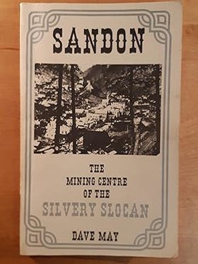
A local history book based in the Kootenay region of British Columbia. Book is fully illustrated throughout with lots of pictures as well as a couple of maps.
viii, 216 p. : ill., maps, ports. ; 24 cm.
CIRC [ 0 ]
Regional District of Central Kootenay
- Ainsworth Hot Springs
- Alamo
- Alice Siding
- Appledale
- Applegrove
- Argenta
- Arrow Creek
- Arrow Park
- Balfour
- Beasley
- Belleview
- Birchdale
- Blewett
- Blueberry Creek
- Bonnington Falls
- Boswell
- Brandon
- Brilliant
- Brouse
- Burton
- Canyon
- Carrolls Landing
- City of Castlegar
- Cody
- Cooper Creek
- Corra Linn
- Crawford Bay
- Crescent Bay
- Crescent Valley
- Town of Creston
- Curzon
- Deer Park
- East Arrow Park
- Edgewood
- Erickson
- Erie
- Fauquier
- Fosthall
- Fraser
- Fry Creek
- Gerrard
- Gibson Creek
- Glade
- Glenbank
- Glenlily
- Granite
- Gray Creek
- Hall
- Harrop
- Hills
- Howser
- Huscroft
- Jersey
- Johnsons Landing
- Village of Kaslo
- Kinnaird
- Kitchener
- Kootenay Bay
- Krestova
- Kuskonook
- Lardeau
- Lebahdo
- Lemon Creek
- Lister
- Longbeach
- Makinson
- Marblehead
- Meadow Creek
- Meadows
- Mirror Lake
- Mountain Station
- Village of Nakusp
- Needles
- City of Nelson
- Nelway
- Village of New Denver
- New Settlement
- Ootischenia
- Pass Creek
- Passmore
- Perrys
- Playmor Junction
- Poplar Creek
- Porto Rico
- Procter
- Queens Bay
- Raspberry
- Remac
- Renata
- Retallack
- Riondel
- Robson
- Robson West
- Rosebery
- Ross Spur
- Rykerts
- Village of Salmo
- Sanca
- Sandon
- Shoreacres
- Shoreholme
- Shutty Bench
- Village of Silverton
- Sirdar
- Village of Slocan
- Slocan Park
- South Slocan
- Summit Lake
- Sunshine Bay
- Taghum
- Tarrys
- Three Forks
- Thrums
- Vallican
- Walkers
- Willow Point
- Winlaw
- Wynndel
- Yahk
- Ymir
- Zincton
Political Boundaries
Last updated: 2025-09-23