Village of Lytton Thompson-Nicola Regional District, British Columbia
Village (1) - A populated place with legally defined boundaries, incorporated as a village municipality under the provincial Municipal Act. At junction of Fraser and Thompson Rivers, Kamloops Division Yale Land District
Mapped Location
Village of Lytton: The mapped location is an approximation and should not be used for navigation or wayfinding.
Information
General information on Village of Lytton
- Feature Type: Incorporated
Official, historical, colloquial and alternative toponyms for Village of Lytton
A brief list of names that this geographic feature has been named
| Name | Description |
|---|---|
| Village of Lytton | Official |
Origin Notes and History of Village of Lytton
References to Village of Lytton that document the origin of its place name
Lytton (Post Office & Railway Station) adopted 6 October 1936 on Geological Survey sheet 408A, as labelled on BC map 2B, 1914. Incorporated as a Village Municipality 3 May 1945; subsequently confirmed as Lytton (Village) (date not cited).
Named in 1858 by Governor Douglas, after Sir Edward Bulwer-Lytton (1803-1873), Colonial Secretary at the time the village was established, and later Earl of Lytton. Note conflicting birth/death dates in some biographical dictionaries. See Akrigg for additional biographical information. Lytton Post Office was opened in 1872 (specific date not cited).
This was once the site of an Indigenous village called Camchin, meaning approximately "crossing over". The short-lived Hudson's Bay Company's Fort Dallas was also located here.
Camchin.....which means "the great fork".
Related Catalog Titles
A Bibliography for Village of Lytton, Thompson-Nicola Regional District, British Columbia
Burning sage poems from the Lytton fire by Meghan Fandrich
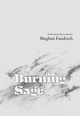
"On the day that Lytton, BC burned to the ground, Meghan Fandrich ran from the flames. She saw the village turn into a black pillar of smoke, and went home after a month-long evacuation to its ashes. Her house, on the edge of the fire, was saved; her community and her small business were not. Life as she knew it was gone, and somehow, in spite of the trauma and the ongoing onslaught of natural disasters, she had to keep going. Living. Surviving. Burning Sage shares Meghan's deeply personal story of the fire, the ensuing trauma, and the path out of it. But it is also a human story, a universal story, of loneliness, fragility and beauty. The poems follow the arc of shock, fear, and anger, and the impossibility of single parenting in a burned-up town. They tell of a connection, a love, and the way that feeling understood can help us understand ourselves. The poems in Burning Sage share a vivid portrait of grief and heartbreak and, ultimately, of healing."-- Provided by publisher
88 pages : illustrations ; 21 cm
CIRC [ 0 ]
DeeDee's Indigenous dream families between St. Elmo and Lytton by Vera Isabel Creighton

Published in 2022 by Vera Isabel Creighton, DeeDee's Indigenous dream families between St. Elmo and Lytton explores the deeply intertwined familial, cultural, and geographic histories of Indigenous communities inhabiting the rugged corridor between St. Elmo and Lytton in British Columbia. Drawing on regional archives, personal narratives, and local genealogies, the book documents the enduring social networks and resilience of families navigating the disruptions of colonial encroachment along the Fraser Canyon. A keen insight drawn from the text is how it shifts the focus away from macroeconomic frontier histories to center kinship and oral tradition, revealing how indigenous family structures served as the primary vehicle for cultural survival and continuity through decades of systemic displacement
122 pages
CIRC [ 0 ]
Thompson-Nicola Regional District
- 70 Mile House
- Aberdeen
- Adams Lake
- Agate
- Village of Ashcroft
- Aspen Grove
- Avola
- Barnhartvale
- District of Barriere
- Batchelor Hills
- Beresford
- Bestwick
- Big Bar Creek
- Birch Island
- Black Pines
- Blackloam
- Blackpool
- Blucher Hall
- Blue River
- Boston Flats
- Brigade Lake
- Brocklehurst
- Brookmere
- Village of Cache Creek
- Cahilty
- Campbell Creek
- Canford
- Village of Chase
- Chasm
- Cherry Creek
- Chinook Cove
- Chu Chua
- Clapperton
- District of Clearwater
- Village of Clinton
- Collettville
- Copper Creek
- Coutlee
- Coyle
- Criss Creek
- Dallas
- Darfield
- Douglas Lake
- Duck Range
- Dufferin
- Exlou
- Heffley Creek
- Holmwood
- Jesmond
- Juniper Ridge
- City of Kamloops
- Kanaka Bar
- Kelly Lake
- Knutsford
- Lac Le Jeune
- Little Fort
- District of Logan Lake
- Loon Lake
- Louis Creek
- Lower Nicola
- Village of Lytton
- Martin Prairie
- McLure
- City of Merritt
- Monte Creek
- Monte Lake
- Nicola
- North Bonaparte
- North Kamloops
- Oak Hills
- Pinantan Lake
- Powers Addition
- Pritchard
- Quilchena
- Rayleigh
- Sahali
- Savona
- Shulus
- Shuswap
- Six Mile Ranch
- Spatsum
- Spences Bridge
- Stillwater
- Stump Lake
- Sun Peaks Mountain Resort Municipality
- Tobiano
- Tranquille
- Turtle Valley
- Valleyview
- Vavenby
- Vidette
- Vinsulla
- Walhachin
- Westsyde
- Westwold
Political Boundaries
Last updated: 2023-10-02